Sunday, May 19, 2013

ICAO vs. 7233-1


We all grew up using the plain old FAA flight plan form (7233-1) that was in the AIM or in the manual we got in ground school. It is the information that the FAA says we need in the order they want it right?
Yes, it is still in the AIM, and it will allow us to get flight following, and all kinds of services. It works in the US.

The 7233 form is in need of updates. This form will still let the FAA know if you have a LORAN equipped aircraft, just use the /I, /C, or /Y. The current set of suffix codes allows the controllers to know if the aircraft is RNP capable, using the /R suffix, but doesn't show how the aircraft meets the requirements, of if the aircraft is RNP10, RNP4 or RNP0.1.

How about that fancy question regarding equipment? If the aircraft GPS equipped, a /G should be filed, or still and older plane with only an ILS and DME, what should be filed. The FAA has plans to change many of the equipment suffix codes August 2013. Mostly the FAA isn't going to care about any performance based navigation (PBN) using the 7233 form. Most of the changes only affect aircraft in the flight levels, that are RVSM capable. The big changes are:

All Mode C transponders (at least, including mode S)
  • /Q - RNP (obsolete)
  • /W - RVSM no RNAV (no change)
  • /Z - RVSM and RNAV with no GNSS (new)
  • /L - RVSM GNSS (any GNSS capability is new)
  • /J - RVSM DME/DME/IRU (obsolete, similar to /W)
  • /K - RVSM FMS with DME (obsolete, similar to /W)

The reality is, and the FAA folks in the know will tell you this, the time has come to retire this old friend. Controllers are like pilots, they grew up on this format, and their flight strips will still use some of this format for a couple years, but mostly, they are being trained on something else.

ICAO form

If you have ever flow to Mexico or Canada you probably had to fill out the ICAO flight plan. Canada calls it the Nav Canada form. It looks intimidating, but it leaves a lot of the guess work out of the above form.


Everything before the "FPL" is not needed. There are links to various instructions for filling out this form. Everything after the remarks (Item 18) is optional. The ICAO has a document 4444 "Rules of the Air and Air Traffic Services" about 4000 pages similar to the FAA AIM for both ATC and pilots. Appendixes 2 and 3 cover the flight plan form, and what text to put where. If the above links are followed the form is easy to deal with. 

The big advantage to using this form is specifying your equipment. If your aircraft has at least one Com radio you put in a V (VHF Radio Telephone), if you have a DME, you put a D, if you can fly in RVSM airspace you put in a W. The suffix is either a C for a mode C transponder, S for mode S transponder or an N for no transponder. Then the suffix beyond that would be for ADS/B. PBN levels can be specified using the R in field 10, but the PBN details must be entered in field 18.


You get to tell the FAA exactly what equipment you want to use for your flight, without interpretation and the FAA will pay attention, and let you use it.

That does mean the air traffic controller may put an aircraft on a GPS approach without asking. That should be a good thing, since it is a little more efficient. You can negotiate the ILS or VOR approach if you prefer still. The ATC computers are reading the flight plan, and offering controllers the most efficient reroute based on capabilities specified.

Going Forward


To start using the ICAO flight plan, most of the flight plan filing services will offer ICAO plans is specified. Select that option, and fill out the plan as before. Specific details for the aircraft will need to be specified when setting up the aircraft, but once set, they will continue to be used for plans going forward.

It would be good it the FAA quit publishing the 7233 form, but that doesn't seem to be in the cards any time soon. There are many publications that still refer to the 7233 form, and they also will need to be changed. We are well past the transition phase, most of the FAA employees are familiar with the ICAO form, and are capable of processing instructions in ICAO format.



Wednesday, May 8, 2013

ADS/B and RNP

There are many uses for the GPS data in and out of the aircraft. The GPS location is very accurate, normally. Knowing where the aircraft thinks it is can help ATC in many instances.

Shortcomings of RADAR

RADAR will send out a radio signal in a cone shape. The farther the aircraft is from the antenna, the larger the target will appear on the radar screen. The location displayed to the air traffic controller isn't as accurate when the aircraft is far from the antenna. The RADAR cannot "see" straight up either, so if the aircraft flies directly over the antenna, the software has to guess where the aircraft will be.

RADAR can only get range and azimuth information. The RADAR cannot determine altitude. Altitude information is sent from the aircraft in  the transponder message. When the aircraft transponder hears the RADAR interrogation, the transponder responds with the transponder code and altitude (with mode-s, there may be more information).

Most short range RADAR has about a 5 second sweep. The long range radars have a 12 second sweep. The sweep time is how long the RADAR antenna takes to turn once. The sweep time is how long it takes between aircraft updates. If the aircraft is going 600knots, and the sweep is 12 seconds, the aircraft moves about 2 miles between sweeps. 

The RADAR software has to do some correlations between the raw RADAR range and  azimuth information, and the transponder code altitude message. Usually, there is only one aircraft that comes into RADAR range at a time at the same point, so it is easy to correlate this, but occasionally two targets may appear at different altitudes at the same place. The software will occasionally get this wrong.

Why ADS/B is Better

ABS/B out messages from the aircraft will usually be the same quality. The GPS accuracy will be pretty consistent in an area, and be very accurate. The target drawn on the air traffic controllers screen will be the same size as the target moves across the screen.

The ADS/B message will contain both location and altitude information in a single message. The software will not need to correlate that data. During times when the ADS/B aircraft are operating in the RADAR environment, correlation will still be done with the raw RADAR and the transponder messages. The ADS/B information will only make correlation more accurate.

The ADS/B location is broadcast about once a second. The controllers screen will update every time it hears the ADS/B signal.

ADS/B will broadcast to the aircraft in the area without relying on ground station. The FAA having two frequencies, 978MHz and1090ES almost requires a ground station for ADS/B to work. There are other benefits to the ground stations, in that they will broadcast weather (FIS/B) and traffic (TIS/B) from non-participating aircraft.

RNP and ANP

In most of this and previous articles I have hesitated on specifying the accuracy of GPS location information. GPS accuracy changes during the day, and in certain locations. The current accuracy is defined as Actual Navigation Performance (ANP) and is measured in miles. Sometimes the ANP will be down to feet in all directions, sometimes it will be in miles.

To fly a GPS approach it is necessary to have an ANP of 0.3 miles or better. 0.3 miles means the receiver is able to pinpoint it's position to less than 1500 feet. The 0.3 mile value is called the Required Navigation Performance (RNP). To fly with any more precision, special training is needed. The FAA has many public RNP approaches with levels as low as 0.1 miles, or about 500ft.

This sounds pretty sloppy, 500ft is bigger than 10 houses.  Remember, the GPS receiver is calculating where it was when it heard the last update from the satellite, but the aircraft is carrying that receiver at 150-200kts on final.  The receiver is throwing values into the Kalman filter as fast as it can, and guessing that the pilot won't turn more that 3 degrees per second, assuming a mostly straight course.  It ain't easy, 500ft is pretty good.

Many commercial aircraft display the ANP and RNP values at the bottom of the navigation display. The display on a 737 is the instrument on the left (see slightly above this link).

NextGen future

There is a lot to NextGen technologies. Alaska has been playing with ADS/B since the late 1990's. The FAA is financing more Capstone work in Alaska even in the time of sequestering. Much of the enroute NextGen requires ERAM, but that is still in process, and is partially on hold until the FAA gets their financial situation in order.

The FAA is currently wanting to require all aircraft to participate in ADS/B out by 2020. There will be some challenges to that. With the current financial situation and things being on hold, will the FAA be ready for all aircraft to be using ADS/B? What about the Luscome 8F that never had an alternator, what will it use to power the GPS and transmitter needed? What will the FAA use to track aircraft with electrical failure?

Some airlines are equipping their aircraft with RNP and ADS/B. Some have had a challenge reaping the benefits from the upgrades. The other airlines are waiting until some indication they will reap some benefits. The FAA and the airlines are still trying to figure out the best time to move forward.


Friday, May 3, 2013

GPS helpers

This is part 2 to the Next Gen article. This article will reference details from the last article. If you don't know the details of how GPS works, you might want to review that article. As in the previous article, when I say GPS I mean all GNSS systems.

Sometimes the GPS signal is not reliable, due to varoius conditions including atmospheric interference, reflections off of terrain and building or satellite maintence. To keep the GPS signal consistent, various groups have come up with augmentation systems. There are two basic kinds of augmentation methods, satellite based and ground based.

The augmentation systems all basically operate the same way. The augmentation system has one or more GPS receivers at a known locations. The receivers calculate the position as best it can. The system then compares the calculated GPS position with the actual location. The difference from the actual position is broadcast to GPS receivers that are in the area, so they can compensate their calculated position the proper amount making the resolved location more accurate.

Satellite Based

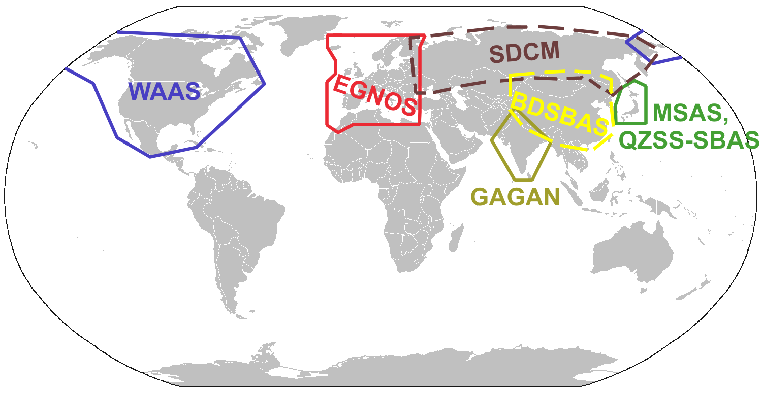
In the US, the satellite based augmentation system (SBAS) is called wide area augmentation system (WAAS). In Europe they have European Global Navigation Overlay Service (EGNOS). Wikipedia GNSS augmentation page has a great map that outlines the various systems proposed for the rest of the world:

The WAAS system uses several ground based stations at known locations throughout North America. The calculated difference is then broadcast to a master station that calculates the Deviation Correction (DC). The DC message is sent to the WAAS satellite. The DC signals are broadcast from the satellite to the appropriately equipped GPS receivers. The WAAS receivers are the ones certified to TSO-C145/C146 standard.

WAAS signals should allow the GPS receiver to resolve the position of the receiver to within 25ft vertically and horizontally 95% of the time. Usually the resolution is closer to 2ft. This accuracy will allow the the receiver to be used for precision approaches similar to the traditional ILS system.

Ground Based

There are two major types of ground based augmentation systems in the US, DGPS and LAAS. DGPS is differential GPS. DGPS users are normally survey crews, and boats. On boats, DGPS navigation is provided by the Coast Guard. Local area augmentation system (LAAS) is the FAA's version. 

LAAS uses multiple (at least 4) receivers around an airport at known locations broadcasting correction signals in all directions. The LAAS correction signal will be broadcast on VHF navigation frequencies using a normal data link.

The advantage of LAAS over and ILS is that all the LAAS transmitters transmit on the same frequency. ILS will require a separate radio, antenna array and maintenance for each runway that the ILS is available for. The LAAS receiver
will calculate the approach path allowing for standard ILS like approaches. The accuracy should be better than WAAS since the difference is focused to a 30 mile diameter.

LAAS isn't not available at many airports today. The experimental LAAS installations have proven the system is quite useful. The system at Memphis has been proven safe since fall of 2006. The Memphis tests have been used for testing RNAV like approaches.

Approaches

GPS approaches are being added to many airport, almost daily. The typical GPS approach will not be as straight as and approach requiring VORs. Most aviation GPS receiver systems will be able to calculate the approach path waypoint to waypoint, where the waypoints are RNAV type locations.

Localizer Performance with Vertical guidance (LPV) is the highest precision approach level below RNP Special Aircraft and Aircrew Authorization Required (RNP SAAAR) approaches. LPV approaches are equivalent to ILS approaches. WAAS can provide adequate accuracy for LPV approaches. LAAS can also provide accuracy for LPV approaches. 

The FAA is able to survey and publish LPV approaches at airports and runways without adding any extra equipment. Many runways that are not suitable for ILS equipment have LPV approaches today, and more are being surveyed all the time. The LPV is typically depicted on the GPS approach chart.

LNAV is a non-precision approach that can be accomplished with almost any GPS. Augmentation is not required for the LNAV approach provided the receiver is able to maintain resolution to 1800ft (0.3nm).LNAV approaches, are similar to VOR approaches for the minimum descent altitude (MDA). The LNAV is also typically depicted on the GPS approach chart.


Next up, we will talk about ADS/B and RNP and how they help keep us out of each others way.

Tuesday, April 30, 2013

Next Gen

This is the first part of at least a 3 part post. I could write one giant novel of a post, but then I don't think as many people would read it, and this way I can break things into logical chunks, so people who understand one subject (IE WAAS) don't have to read that.

GNSS Basics

GNSS stands for Global Navigation Satellite Systems. That means there are signals coming from satellites that help you know where you are. In the USA there is the GPS system, Russia provides GLONASS, China is building Beidou and the EU is building Galileo. While they all generally do the same thing, they all do it slightly differently, and on a slightly different radio frequency. All the systems do is tell you what time the satellites think it is, very accurately.

I'll say GPS, when I mean any of the GNSS systems, just to make things consistent and short.

All the GPS systems do, is tell you where the satellites are at the moment they sent the time. Since all they do is tell you what time it was when the signal was transmitted. When the GPS receiver hears the message containing the time, and the location, it can calculate how far away the satellite was when the signal was transmitted. Knowing how far away the receiver is from 3 points will give a pretty good idea of where the receiver is. Knowing how far away from 4 or 5 satellites will give even more accuracy, indicating elevation, as well as position on the surface of the earth.

Since the receiver doesn't really know where it was when it was turned on, it needs a couple minutes to figure out all the possible positions it could be based on the number of receivers it can hear, and how far away from them it is.

Radio signals are pretty reliable, but sometimes they are interrupted, or bounce around. Ever have some ghosting images on a TV from signals being delayed to the TV receiver? The same thing can happen with GPS receivers. Various atmospheric conditions can delay or accelerate signals. Close to the ground in an urban setting can be the worst, since the signals will bounce off of buildings and vehicles making the receiver work extra hard to figure out where it is. If a signal just doesn't make any sense to the receiver, it can reject that signal.

The satellites are moving at around 17000mph, the earth is turning at about 650 mph and the receiver may also be moving. The earth is not round, it is egg shaped (average). The math gets quite complicated. There are some handy mostly simple formulas to get latitude/longitude math at http://williams.best.vwh.net/avform.htm. Add in some other math to calculate the movement, and now things get all kinds of fun.

Since everything is moving, sometimes several satellites will not be in optimum positions to let the receiver hear them. Some be very close together, straight up, or some may be close to the horizon. If they are all bunched up in the sky, their time will all be the same, and it will be hard to differentiate between the signals. Likewise when the satellites are close to the horizon, they will subject to more interference, either through buildings or mountains.

The GPS constellation has about 32 active satellites. That means 16 are on this side of the earth and 16 are on the other side. Actually it will be maybe 12, since probably 4 of the 16 are too low on the horizon just rising, or just setting. Sometimes too, the satellites are having maintenance done on them, with software upgrades, or other tests. Hearing 8 satellites in any day is a really good place to be.

Because of the dynamic nature of the satellite constellation and the earth, and the vehicle we may be in, sometimes we don't get a good signal. The quality of the signal can be predicted. The FAA provides a web site that will show the current and future signal quality for the USA. If you use java in the browser the tool is very dynamic: http://www.raimprediction.net/applet.php Looking at the top of the page, there are also summaries. When they show a red area, that means the accuracy quality worst case is not able to be met for that time period. The 3 levels they show are enroute = 2miles, terminall=1mile, NPA=0.3 miles.

GPS is giving the position of the receiver in 3 dimensions. GPS can calculate latitude, and longitude as well as altitude. If the latitude is off by 0.3 miles, that means the altitude is also off by around 0.3 miles, or 1500 feet. Vertical guidance by GPS seems a huge challenge. Many aircraft receivers have an option for barometric aiding. The altimeter in the aircraft works by measuring changes in barometric pressure. The same concept can be used with the GPS receiver. By feeding the receiver with a know barometric pressure, it can more accurately calculate altitude.

Various GPS receivers are available in the aviation market that are built to various standards. Most of the early GPS receivers installed in aircraft were certified to a TSO C-129 standard. Some aircraft may have TSO C-196 standard receivers as well. The C-129 and C-196 receivers are able to receive GPS signals and may be enhanced with some kind of barometric aiding. The more popular standard these days are the TSO C-145/146 standard receivers. The C-145/146 receivers are able to receive WAAS signals.

WAAS is a Satellite Based Augmenation System (SBAS). WAAS stands for Wide Area Augmentation System. WAAS is another satellite or constellation that broadcasts correction values to GPS receivers. The WAAS system has a few ground based systems at known locations measuring the difference from the GPS broadcast position and where the location really is. Receivers listening to the WAAS signal can adjust the calculated GPS position using the known difference to be more accurate.

Any aircraft flying relying completely on GPS navigation is required to make a pre-flight check. If the receiver is using the C-129 or C-196 standards, then a full RAIM prediction must be made. The above map at http://www.raimprediction.net is sufficient. For aircraft using the C-145/146 standard receivers, then a check for GPS NOTAMs is required.

GPS Receiver Systems

A typical aviation GPS receiver is really a system. The GPS receiver can only tell you where it is. Typically the GPS receivers are connected to computers that are watching where they have been, and projecting where they are going. There is a function that can be used to smooth out the path, and predict where everyone is going called a Kalman Filter. There is some mapping software that holds the location of most of the waypoints for the region. The computer is also connected to a display to the pilot can see where they are, and enter a flight plan.


Next time I will talk more about augmentation systems. The third part will be about RNP and ADS/B.

Thanks for reading, and I look forward to some feedback.

Monday, April 29, 2013

Batteries in Airplanes

Batteries seem to be a popular subject these days. Certainly the 787 has had it's share of trouble. Even a couple years ago, batteries in phones and laptops were catching fire, seemingly randomly. Mostly the fires have been harmless to people, but the equipment hasn't come out so well. During 2007 there were several laptops that spontaneously combusted Here is one (warning coarse language) http://www.youtube.com/watch?v=mlZggVrF9VI. Several manufacturers had recalls, and since then, there haven't been too many laptops that caught fire..

About the time everyone figures the trouble is over, people start getting burned with cell phones in their pocket. I have a couple batteries from my previous phone that are slightly bulged. The bulges signify something bad happening on the inside of the case. Bulging is a mechanical function, charging is normally a simple exchange of electrons.

I don't know the details of the 787 exactly, just what I have read, and the pictures I've seen. It seemed the original design had multiple cells packed together inside of the blue box. The new design has insulation between cells, and the cells are isolated. Lithium batteries are more likely to fail when heated. If one cell is misbehaving and getting warm, and touching another cell, the non-warm cell is more likely to do something bad, even though everything about it is normal. The misbehaving cell will inspire the adjacent cell to enjoy its company. Their friends may joint in, being neighborly, and things are getting quite hot now. The heat seems to multiply, especially being in a box, and suddenly there is smoke coming out.

There is a theory that all electronics run on smoke. When the smoke gets out, they quit working. Batteries tend to be the source of smoke for many electronics, so when the smoke gets out of them, things really don't work.

Why would anyone put something that dangerous in their airplane? As Collin Chapman used to say about building race cars, "Simplify, then add lightness", or Burt Rutan used to say, "Throw it up, if it comes down, it doesn't belong on your airplane". Basically what these people are saying, that making things light is the proper way to build airplanes, and cars. Why lithium? Look at this table:

    -----------------------------------------------
      Fuel        |             Watts / Kilogram
    -----------------------------------------------
    Lead Acid     |            0.05
    -----------------------------------------------
    Lithium       |            0.224
    -----------------------------------------------
    Gasoline      |           12.88
    -----------------------------------------------

Lithium batteries are much lighter per unit of work (watts).

Wow, that does seem dangerous, or does it. Well, it is significantly more dense than a lead acid (the traditional airplane battery, although some airplanes are now ni-cad powered), and quite a bit less dense than gasoline. No one carries gasoline in their pocket.

How much battery does an airplane need. I built and airplane once, and was told I only need enough battery to start the engine. Once the engine is started, then the Alternator should take over powering all the accessories. All the radios, gear retracting motors, and lights all run off the alternator. A bigger battery might be handy in case the alternator quits, but then you are hauling around a battery for every flight that you may never need. A second "back-up" battery is just extra weight that you haul around.

Airplanes should be designed so failures are an inconvenience, not a catastrophe.  If your alternator fails, you know the battery will be dead eventually. Once it fails, you can continue without radios and such, or you need to land before it gets dark. With a backup battery, you may continue farther, but you will still need to land soon.

In a modern jet airliner, there are alternators on each engine. Two seems like a good idea. There are actually 3, since the aircraft actually has a third turbine engine called the auxiliary power unit (APU). The APU is hidden in the tail of the aircraft, and connected to a generator capable of starting both engines, and running the majority of everything electric in the aircraft.

The 787 is unique, in that there is no hydraulic system to help the pilots fly the airplane. The items normally controlled by hydraulic fluid are run by servo motors, including control surfaces and brakes. The electrical system is quite important.

The batteries will help start the airplane. On the ground, there will usually be a device called a ground power unit (GPU) that will allow the aircraft to be started. The GPU can also be used to charge the batteries.  If the aircraft is operated away from the GPU, the battery will usually start the APU since that is a smaller turbine. Once the APU is started, it will be used to start the other engines.

Will the new battery solution help prevent a catastrophic failure on the 787. Probably, since the misbehaving battery cell will be isolated from its neighbor. Will there be cell failures? Probably, but the new monitor system will alert the pilots, and isolate the bad cell when needed.

If someone wants to have a wanna be engineer to ride around on the 787 during test flights, I'll volunteer. Give me a call, we'll set something up.


Saturday, April 27, 2013

Sequestration Ha!


I was going to write something about the furloughs and why they would cause the delays that they do, but I think everyone has heard enough. Now that they are over, it may not matter, but then again, how are they going to end...

So in a contract position, a fraction of the workforce was forced to reduce their work by 10%. Everyone is supposed be treated equal, so how can this be, not everyone had their work cut by 10%? How are they going to make it fair? The whole mess will take over a month to resolve, unless there is an emergency order, causing the folks who got the time off to be paid for the time they took off anyway (such a deal!).

I don't know if the whole deal was worked out yet. Sure congress got beat up, and something happened, but has the President signed off on it (does he need to, I am thinking he will eventually). The whole deal is a rob Peter to pay Paul anyway. No one authorized the FAA to spend what they used to spend, just that they can use some other money to pay the controllers. That money is still ready to be used for the projects it was originally intended to be used for, and someone else will be screaming if they don't get theirs.

Why do to furloughs cause delays? In a air traffic control center, there are various geographical regions that are covered, broken into sectors. Not all controllers are certified to work all sectors. The midnight shift will combine multiple sectors and work them together, where during the day, a single controller or team (RADAR (R) and Data (D) side) will work a single sector. If you don't have enough staffing, the number of controllers certified to work the sectors will be reduced.

One day the guy certified to work sectors 1,2 and 3 will have the day off, and the next day the guy certified to work sectors 2,4,6,8 will have the day off. Scheduling becomes a challenge. Then throw in vacations, and sick days, and some days you may only have one guy on a shift qualified to work sector 5 or something. For one guy to handle the sector, then only maybe 12 aircraft can be in the sector at a time. Maybe it is a gateway sector, and he is doing his best but that means that sectors 6 and 4 have to hold or slow down aircraft. Slowing aircraft has a ripple effect, and sectors 3 and 7 have to manage the aircraft coming into sectors 6 and 4 smartly (and so on).

Equipment went from same day repair to next day repair. It wasn't just the controllers on furlough, but tech support as well. If the only person who normally would be on staff certified to repair some piece of equipment was off that day, the equipment was out of commission. Maybe it was not terribly critical, but caused more inconvenience to the controller, they will have to slow even more.

So traffic backs up all day, and the airlines are taking delays. (travelers still bought tickets, and they want to get where they are going). There ends up being higher volumes of traffic at some airports until well into the midnight shift. The midnight shift that is short staffed with overlapping sectors. All the FAA can do is ask some of the night shift controllers to stay late (and pay them overtime) since the sectors will be impossibly full until even later. So everyone is taking a 10% paycut, but to make that work, the FAA has to pay overtime to some of the staff. 

Since the first week required one third to half the staff to take a day off, how is it that the other folks are going to balance that out? Again, with vacation and sick days, to make it fair, it'll probably take a month for everyone to have the same hours. I know it says that they will "fix" it by Monday, but how can that be? There were controllers who decided the whole government employment situation is silly, and took their retirement, or just quit once they got threatened with the furlough.


It kind of begs the question, who is in charge? Congress tells the FAA to cut spending, and the FAA says we can cut this or that expense, and congress says no, not that one. Why have any administrators if congress is just going to override their decisions. Tower closures were overridden. For many years the FAA has been trying to consolidate TRACONs and such to save money, but it seems someone in congress forces the FAA to not do it. Congress talks the big talk, cut, cut, cut, but when they do, they say "not that way".


Thursday, April 18, 2013

Routes to Nowhere

Even professionals do silly things sometimes. Take a look at this approach plate for Nashville Tennessee.
Click to Zoom
The other day I saw a route from MDW to this airport that was something like

   CARYN2 CARYN J73 BNA

It seemed ok, pretty simple. I remember a controller telling me once, you don't want a clearance to an airport, you want a clearance to your approach, especially in the radar environment.

Look at the plate again, BNA! that is a VOR on the airport, but it isn't an initial approach fix (IAF). The FIDDS intersection is the IAF for this approach. Even from the North to the 20's runways, BNA isn't an IAF. 

So this poor pilot was cleared to a VOR. What should the pilot do if he looses communication? Assuming this was a ICAO flight plan, the destination airport was in field 16, no big deal. ATC should know where you want to end up. But what should this pilot do when they get to the BNA VOR in the soup? (assuming they have ILS or VOR receivers but no COM, it could happen).

Even if the pilot had good radios, and was planning on the ILS 2L, what should the controller tell this poor pilot? Well he has to figure out a way to this approach. Using the 2's, no big deal, since BNA is mostly on the way to FIDDY. Imagine though, the pilot wanted to go to the 20's. The IAF for the ILS 20R is HIKRY. HIKRY is 20 miles to the north. The pilot still gets to fly 40 miles more than needed to plus two huge turns. It isn't that far, but the pilot is still in the airport traffic area and has the controller guessing what to  do with this aircraft, to keep the pilot out of the way of all the other aircraft.

If the flight plan were filed to the IAF, or better yet, to a transition point on a STAR, so the sequencing can be done easier. The controllers like to know where you are going as far out as practical. The controllers like more time to think, and plan ahead, knowing what is planned, things go smoother.

Probably the proper route would be (ICAO format):
     CARYN2 CARYN J73 PXV DCT FIDDS

Getting off of J73 at PXV is safe and about as direct as you can get. It is 128 miles and gets the aircraft on the ILS 2L without any questions. The controller can assume the aircraft is going on the ILS, assuming ATIS says ILS 2L approach is in use.

I am hoping this helps. Any other thoughts?