Thursday, December 5, 2013

Air Data and FMS

I missed a bit in my last post about FMS's. (I am shortening everything to FMS,
it is mostly the same thing, a system). Air data, what is that...

Air data is usually known as the pitot static system on smaller aircraft. Getting the pressure information into the aircraft involves a analog to digital (A to D) conversion.

All aircraft have pitot tubes to measure air pressure because of speed. Pitot tubes are closed tubes, and the airspeed indicator, or air data computer only can measure the pressure of the air trying to get into them. Larger aircraft may have multiple pitot tubes on them, for redundancy mostly. The airspeed indication is made by comparing the difference in pressure from the ambient air, and the pressure forced in the pitot tube.

The ambient air pressure is entered to the system through static ports. There are multiple static ports on most aircraft. The static ports also help measure altitude and rate of altitude change (vertical speed indication). Again the static system measures change in pressure, from ground level to altitude.

There is a relativly simple formula (thanks to wikipedia) for incompressible fluids  pt is total pressure, ps is static pressure, p is density. V becomes the fluid velocity, or airspeed for us.


V = \sqrt{\frac{2 (p_t - p_s)}{\rho}} Air is easily compressible, and that makes the formula a little more complicated, since you have to integrate pressure and stagnation values.

Static pressure is a little easier. The air pressure doesn't change at a constant rate as the aircraft flies at a higher altitude, but the curve is relatively constant. Thanks to engineering toolbox we can use:

  p = 101325 (1 - 2.25577 10-5 h)5.25588  

p is air pressure (millibars) and h is height above a fixed point in meters. To get the whole formula, you need to include temperature, and humidity as well, see the wikipedia entry if absolute MSL needs to be measured.   

A small transducer can measure the different pressures, and provide a voltage that the computer can read. Computers are good at math, even complex math, allowing us to have usable information on heads up displays, tapes and other graphical presentations.

The air data computer reads these transducers, and puts the data into a usable format that the FMS can use.

The FMS allows setting marks called bugs on the instruments. If the pilot wants to fly at 250kt indicated airspeed, they may enter a command on the CDU keyboard, it will display on the airspeed indicator. The FMS also allows setting heading bugs, and feeds the flight director when flying on a flight plan.

There are more things in the FMS as well, and as I have time, I'll keep adding to the blog.

Write, and let me know what you think


Sunday, December 1, 2013

FMS FMC and how airplanes know where to go.

Flight Management, how does the airplane know where it is, and where it ought to go. The pilot may want to be in charge, but his job is to manage the systems. There are many systems in an aircraft, and many come together in a single computer called the Flight Management Computer (or Flight Management System). The pilot can use the FMS/FMC on the airplane to help manage these systems.

The heart of the navigation system are the gyroscopes and accelerometers. The gyros are known as the Inertial Reference System (IRS). The IRS will be used to measure changes in flight orientation. The IRS will output heading, attitude and change being imparted. Gyroscopes will measure current conditions, accelerometers will measure the change being imparted on the current conditions.

Gyroscopes are great tools for use in aircraft. The horizon gyroscope will hold true through many oscillations of the aircraft, climbs, turns and dives it will usually show the blue side up. The bank gyro will also handle climbs, turns and dives. The directional gyro will maintain heading for hours.


Accelerometers will measure the forces acting on the aircraft in the various directions. As you were taught in instrument training, or perhaps in private pilot ground school, the seat of your pants isn't accurate at measuring change in coordinated flight. Accelerometers are like the seat of your pants, measuring g forces in three directions (forward/rearward, left/right bank and pitch). They will inform the pilot, or flight management system if the aircraft isn't in coordinated flight, or the increase or decrease of thrust is having and effect.

Integrating the accelerometers and the gyros is how the aircraft can measure where it is relative to where it started. When the aircraft is initialized by the pilot, the current latitude and longitude are entered or received from the GPS system. As the aircraft changes position, the accelerometers will measure the forces acting on the aircraft from the TUG as it pushes the aircraft back from the gate. When the aircraft is in flight, turns can be measured by combining the angle of  bank, and the "vertical" acceleration to measure the horizontal component of lift (HCL), and compare it to centripetal force, to measure the rate of a turn.

A couple posts ago, I was going to talk about Kalman filters. This is where the Kalman filter pays dividends. The Kalman filter will take data that isn't perfect, and make some sense out of it. Sometimes gyros or accelerometers will measure unreasonable values, some large, some small. The Kalman filter will make a best effort to use that information in a way that is reasonable (it may throw the data away, or it may smooth it, such that it looks like a normal reading).

The gyros precess. Since bearings and motors are not perfect, the gyro won't always hold the proper heading for the entire trip. A certified IRS should be accurate to about 650 meters in 1 hour. That means that the aircraft know where it is in the world with a 650meter sphere around it. Most modern aircraft will update the FMS with GPS information, allowing the IRS and the GPS to argue about who is more accurate.

The IRS will output all this information, and the FMS will work together to let the pilot know where the aircraft thinks it is. The FMS will talk to the autopilot, and allow it to make corrections to insure the aircraft gets to it's destination.

The FMS will display what it knows to the pilot through various displays. The primary flight display (PFD) will show the pilot the location it thinks it is, along with what is around the aircraft. The control display unit (CDU) will be the user interface where a pilot can enter flight plan, and other information. The ailerons, rudder and elevator will adjust to make the aircraft head to the programmed direction.


When the aircraft is initialized, the pilot will enter a flight plan. The plan will include airports and other waypoints that the aircraft will be flying to. The FMS will also contain the navigation database. The nav database is where all the waypoints are defined, and any important information about them. The nav database is how the FMS uses the IRS data to know if the aircraft is heading to the proper place in space or not.

 About here is where I need to talk about autopilots, and I am running out of space. I'll talk about autopilots in another post.

Keep me up on your thoughts.

Saturday, November 9, 2013

ACARS - How Texting Works

Okey, texting with airplanes happens all the time. It is part of the whole process. The pilot needs to know stuff, and without tying up the air with a bunch of information the pilot may mis-interpret, or need to read later, the pilot and folks on the ground can communicate with a medium most of use use, in text.

In most aircraft, there is a keyboard and a screen up near both pilots. They have the ability to use this device to send questions to the ground, and the ground has the ability to send messages up to the pilots. Information can include weather, or flight plan changes, gate assignment. Almost anything can be sent to the pilots on the screen.

For the most part, this system works similar to a cell phone. There are ground stations all over the country. These ground stations listen on certain frequencies for a signal on a certain frequency. when these ground stations hear a message, they forward it to the assigned receiver. Each airline has assigned address(es). Delta doesn't want United hearing their messages, as much as Jet Blue doesn't want Southwest hearing their messages. Each aircraft has its' own address as well.

These ground stations are owned by various carriers, similar to cell phones. ARINC and SITA are the two major players in the world. There are some smaller carriers as well, and they are limited to certain regions in the world. The carriers don't typically inter-connect messages. If your airline is using ARINC all messages will be on ARINC equipment once they leave the operations center, until they get to the aircraft.

Different stations in the world use different frequencies so the aircraft don't overcrowd a single ground station. The ground station frequencies are similar to the VHF navigation and communication frequencies already used on the aircraft. Most of the ACARS frequencies are in the 129 to 137MHz range. Each ground station can cover about 200 miles on these frequencies.

If a pilot wants to send a message to a dispatcher in the pilot's airline operation center the pilot would tune to the nearest frequency that is on their chart, and enter the message on the keyboard. The message would get transmitted to the ground station and the carrier would forward the message to the operations center for that airline. When the dispatcher receives the message, they can enter a response. The dispatchers response will be forwarded to the carrier, and based on the last known location, the carrier will forward the message to the nearest ground station. The ground station will send the message to the aircraft.

There are a couple 'if's above. The communications protocol is quite robust, allowing for queued messages to stay queued until the ground station receives the message, and acknowledges it. If a ground station is out of service, or the aircraft is tuned to the wrong frequency, the message will sit on the aircraft, until the situation improves. If nothing else, the messages will be cleared when the aircraft power cycles itself (IE shutdown, and brought back up), no one wants to hear about something that happened yesterday.

There are automatic messages sent over ACARS as well. When the aircraft is first powered up, and the pilot initializes the computers a message will typically be sent to the operation center. This message will go into a database, and allow the airline to look at when things got started, what flight the aircraft is assigned to, and other such information. When the doors are shut, and the brakes are released an out gate time message will be sent to the operations center, and when the aircraft squat switches are showing no weight on wheels, an off ground message time is sent. The time messages that the operations center knows about and uses are called the OOOI (ooey) times, Out gate, Off ground, On ground, and In gate. There are other times, like in range that the gate wants to know about as well.

The pilots will use ACARS for many operational items. If ATC needs to divert and aircraft, the ACARS will be a way the dispatcher and the pilot can determine if there will be operational impacts to ATCs request. Will there be enough fuel to take the new route, or will the new route cause people to be delayed are all considered. If the pilot needs to know about weather ahead, some airlines have the capability to send messages to the aircraft if there are significant changes to the weather.

The ACARS unit will ding when a new message comes in. This ding is handy should the pilot be working a situation in the air, and need to know when the resources on the ground have more information. The ding can be a distraction when the pilots workload is high. Most airlines limit the ding to when the aircraft is above 10000ft. Messages can still happen when the aircraft is below 10000ft, but the ding will not distract them.

Next time you are flying, and you wonder where the pilot got all the up to date information, it probably came over the ARARS unit on the airplane.

Thursday, November 7, 2013

CPDLC - Texting For Pilots

Texting and driving is against the law. Texting and flying, no problem. 

Ok, we aren't talking about your family  asking you to stop by the grocery store pickup some milk on the way home. On most commercial aircraft there is a text based communications system. This is usually the ACARS system, the Aircraft Communications And Reporting System. This display and keyboard is right there usually in the panel, and encouraged to be used in flight.

The ACARS communications start early in the flight. Most airlines participate in the Pre-Departure Clearance (PDC) program where the pilots get the clearance right from the tower on the ACARS screen. The pilot is required to request the clearance before the flight, and the tower will automatically deliver the clearance to the screen.

The ACARS system is also connected to the aircraft maintenance department. The engine and other parts of the aircraft are connected to the computers that are connected to the ACARS system. When the aircraft is in a certain state, an automated message will be delivered to the ground. Engine status will be delivered when the aircraft is in cruise state, and not accelerating (stable cruise report). On ground time will be delivered when the aircraft has main gear down.

Recently, ICAO has standardized the phraseology and the FAA have started delivering ATC messages to the cockpit. The messaging is called Controller Pilot Data Link Communications (CPDLC).  There are some limitations to these messages, generally they will be standard communications. Things like "turn left heading 240 degrees", or "climb and maintain 360". These are normal mundane type messages that the controllers say everyday over and over. The ATC screen has templates of these standard messages, where the controller only need to enter the heading and altitude.

The messages must be acknowledged, or they will be assumed to not be received. The pilot can acknowledge the message or say unable. The controller has the option of using the voice to find out more, or offer a better different message.

There is a huge misnomer, Air Traffic Controllers don't actually control aircraft. The controllers offer suggestions to pilots. Pilots can always do what is needed to operate the aircraft safely, regardless of what the controllers are telling them to do. Normally following the controllers directions will be the safest thing to do, but there is always the option.

The ICAO 4444 document Procedures for Air Navigation Services Air Traffic Management has a chapter on the CPDLC messaging.

    CHAPTER 14. CONTROLLER-PILOT DATA LINK COMMUNICATIONS (CPDLC).


There is another document 9694 Manual of Air Traffic Services Data Link
Applications
that has additional guidance. These CPDLC messages have various levels of urgency, and alerts, and are outlined better in these two manuals.

There is a fear that using CPDLC will prevent pilots from eavesdropping on other pilots. There is a possibility that may occur. CPDLC message are addressed to a specific aircraft, and to a specific ATC center. Normally, when ATC is talking (using voice communications) to the aircraft in an area, they talk on the one frequency that all aircraft can hear. The benefit to that is that if aircraft are near each other, and a command will make another pilot question the intention, the eaves dropping pilot can ask for clarity. Sometimes controllers make mistakes, and pilots can ask. If someone is put on the same altitude and opposite course as another aircraft, the pilot not getting the command make question the controller. With CPDLC addressed messages, other aircraft cannot "hear" those commands.

Mostly the CPDLC systems are in use in the oceanic realm. There is quite a bit of separation going on in that area, and communications has been poor over the ocean. In the past, the oceanic communications, has been over HF voice channel. CPDLC has actually improved the performance of the communication over the ocean.

Long term, some CPDLC messaging will be added to the enroute area. Perhaps to a limited extent, the TRACON will start to get some CPDLC messaging.

Saturday, October 5, 2013

UAT or 1090ES?


If you are considering ADS/B, there is a choice to make. Do you install a Universal Access Transceiver (UAT) or the Mode S transponder that has an extended squitter (1090-ES)? It all depends...

What country are you in? If you aren't in the USA, then the choice is pretty much made. The USA offers the option of a UAT. The rest of the world needs Mode S transponders for ADS/B installations.

If you are in the USA, and you mostly fly above FL180, then the choice is pretty much made again. The FAA doesn't allow aircraft flying above 18,000ft to use the UAT. It just makes sense to get the 1090-ES transponder that will do Mode S if you want take advantage of ADS/B and fly about FL180.

The UAT transmits and receives on 978MHz, the 1090-ES transmits and receives on 1090MHz. The ADS/B system will allow all participating aircraft to see each other. If the two devices work on different frequencies, how does a 1090MHz transceiver see a 978MHz transceiver? The ground stations will repeat the 978MHz messages on 1090MHz, as well as repeat the 1090MHz message on 978MHz. The ground station will also show both messages on the "RADAR" scope, so the air traffic controller knows where everyone is.

The FAA separated the two systems for a couple reasons. The 978MHz devices can handle more data (has more bandwidth), so more aircraft in a concentrated area will work without overloading ground stations or other aircraft. The 1090 Mode S transponders are already on the larger faster aircraft that are flying higher, so the expense should be minimized (I am repeating the FAA here, in reality, most operators will need to replace the transponders they have to get the extended squitter feature).

The UAT's are even more useful, since the FAA will broadcast extra information. The two extra messages that the FAA is broadcasting are the TIS/B and FIS/B. The 1090-ES system will get TIS/B, but not FIS/B.

TIS/B is Traffic Information Service-Broadcast, where non-ADS/B equipped aircraft will show up on the aircraft display, similar to ADS/B equipped aircraft. The ground station will broadcast the position of aircraft that are only visible on RADAR. As a pilot, you will be able to see more of what the controller sees.

FIS/B is Flight Information Service-Broadcast. Flight information includes weather, and aeronautical products. While XM provides some weather, that you must subscribe to, the FIS/B is free to everyone. The XM product may have additional information, or be more timely. The FIS/B data is what the FAA will be looking at, including potentially air traffic control. The aeronautical products appear to be weather like items, such as NOTAMs and SUA status.

Exactly what device to get will depend on the capability of the chosen display. Many of the MFD manufacturers will take either device for input, the displayed information may help make the choice. Some will show the weather RADAR information in great detail, others will show it blocky or not at all. Over the next couple years, the MFDs are sure to get better.

Should you wait, or should you buy today? Today the ADS/B MFD technology is being developed. Over the next 5 years, the technology will surely mature. Having ADS/B in on a tablet computer will allow a pilot to get their feet wet, sooner. By 2020, most aircraft will be required to have ADS/B out, which probably means, unless someone builds an under $1000 solution to ADS/B out only, most aircraft will be equipped with ADS/B in and out.

Can you get rid of your transponder once you have ADS/B? No, the Mode/C component will still be needed for RADAR service and TCAS for non-ADS/B equipped aircraft.

It'll be an interesting couple years going forward. What do you think?


Tuesday, October 1, 2013

DO-178C Reliability


DO-178C quantifies the level of safety needed for an aircraft software system. In an aircraft there are various software systems. Some systems are benign, others are safety critical. Something like a reading light in a passenger compartment would be benign system, if a failure were to occur, the safety of flight is not compromised (unless the passenger throws a tantrum!). In a fly by wire aircraft the control system is generally considered critical to flight.

DO-178C is a standard maintained by the RTCA. The RTCA is a group of aviation professionals that manage standards. It provides a place for manufacturers, user and regulators to come together and provide a consensus of regulations and guidance to managing the technology used in aviation. DO-178C is the guidance the FAA (and other regulation bodies) use to insure avionics and other software systems are certified to the proper level.

DO-178C enhances DO-178B. DO-178C standard was available starting Jan 2012, and was used to update the FAA AC 20-115C during the summer of 2013. There are companion documents related to software, tools, formal methods and testing.

There are 5 safety or Design Assurance Levels (DAL) for DO-178C.
  1. Catastrophic - Failure may cause multiple fatalities, usually with loss of the airplane. (level A)
  2. Hazardous - Failure has a large negative impact on safety or performance, or reduces the ability of the crew to operate the aircraft due to physical distress or a higher workload, or causes serious or fatal injuries among the passengers.  (level B)
  3. Major - Failure significantly reduces the safety margin or significantly increases crew workload. May result in passenger discomfort (or even minor injuries).  (level C)
  4. Minor - Failure slightly reduces the safety margin or slightly increases crew workload. Examples might include causing passenger inconvenience or a routine flight plan change.  (level D)
  5. No Effect - Failure has no impact on safety, aircraft operation, or crew workload.  (level E)

Like any software project safety, security and quality start with planning. It isn't very easy to add security to an existing product, likewise it may not be easy to add safety and redundancy to an existing product.

DO-178 requires documentation. Items such as the Software Requirements Document (SRD) and the Software Design Description (SDD) are a good idea for all software projects they are required for DO-178 certification. Additional documents include Software Verification Cases and Procedures (SVCP) outlines how the software will be tested, and Software Verification Results (SVP) kind of proves that the SVCP was actually done, and the items passed or not.

The typical deliverables for a DO-178 project will include the SRD, SDD, the executables, the SVCP and the SVP. Additionally there may be code coverage test results to insure the test results hits all good and bad situations. If the software product is an upgrade to an existing package, there may be other documents that include Software Configuration Index (SCI) like the source code control system documentation, and the Software life cycle Environment Configuration Index (SECI) to outline the development and improvement process.

Typically a Designated Engineering Representative (DER) will review the deliverable to insure the system meets the level of certification desired. The DER may work for the company developing the product, or be an external consultant.

There are various tools the developers and the testers can use to insure the certification process was followed. Starting with the documentation there are templates.Web based compliance verification tools are available. DO-178 software test suites are also used.

Some vendors will suggest that a level A certification is something to shoot for. Actually, for any system, the lowest possible level should be what the designers should seek. In an ideal situation, any failure should be an inconvenience, not an emergency. If the engines are running, and the flight controls work the aircraft can be flown to a suitable facility where repairs can be made.  

DO-178C is a robust standard that can apply to all software development. DO-178C is required for aviation software systems, and provides customers with piece of mind with regard to systems on the aircraft.

Saturday, September 28, 2013

Here We Go Again


We get to get the threats of the "sequestration" again this fall. Of course we knew about it for most of the last couple years, and who has done anything about it? How about that, the only one who could do something, is congress, the same ones who chose to ignore the trouble.

Congress will play the same game of chicken again this weekend. Nothing new there.  Something will be the pawn, this time it is Obamacare. Fine, whatever, I really don't think we need congress messing with health insurance anyway, I can't see how they can make it better. (this conversation could get recursive about here, so I won't get into congress and health care).

The trouble is, the game of chicken costs everyone more money! Obamacare is in progress, and states have put money into making it work. The money is in the federal budget already, and could be funded. If congress tries to unwind Obamacare, well there will be money wasted by the states, and the fedral government that are working toward the Oct. 1 deadline. Corporations have their HR software ready, the rules were set over a year ago.

So they decide to boot the government out on Oct 1. Well, those government employees just go home, and watch daytime TV and don't get paychecks. Hmmm... they don't buy cars, and limit grocery purchases, and that ripples down to the Best Buy store, and the stock boys at the Albertson's. Yes the whole mess puts a strain on everyone, depending on how long things go on.

Lets see, air traffic control is in play again. Will congress like having their flights delayed? Maybe once, or maybe they have things rigged to not be personally affected this time. If they are delayed, you can bet congress will make a strong effort to adjust budgets to make that part less painful.

How is traffic affected by controllers?

As I wrote in my April Sequestration post, controllers are certified to work a limited section of airspace. If all the people scheduled to work a day can't cover a sector, then planes can't fly in that sector. There are also rules about how long a controller can work a sector without a break (bathroom and lunch breaks are not optional!).

Airspace in IFR conditions is positive control, or only one aircraft can be in a part of airspace until it is known where that aircraft is. I've flown IFR to Livingston Montana in a small airplane before. Livingston is in a valley, and unless you are over 12000ft up, there is no RADAR coverage, and there is no tower at the airport. Once I left Billings MT RADAR area, I was cleared for the approach into Livingston. That meant the controller gave me all that airspace, until I told her that I was on the ground, or back into some other controlled airspace. The controller had to give me exclusive access to that airspace, since she couldn't see me, and she wouldn't know where I would be relative to another aircraft.

If towers are closed the enroute controllers will give the aircraft the airspace around the airport, starting sometimes over 50 miles out. That means only one aircraft can be in that 50 mile area until it is on the ground, or reports that it is going somewhere else. With the tower open, the spacing can be 5 miles between aircraft. With the tower closed it maybe 50 miles of spacing. You can get 10 aircraft on approach with the tower open, and only 1 with the tower closed. Things slow down really fast like that.

Airplanes don't care if the towers are contract or FAA run. If there is proper staffing, then the pilot can fly closer to other aircraft. The aircraft won't have to hold or divert if there are enough people at the tower watching aircraft. There are towers that handle very little traffic, and the staffing could be reduced, and the FAA has tried, but usually some congress person has a special interest in that tower, and it stays open for many hours with few operations.

Again, as flights get late, the second shift or the midnight shift get to work overtime. Congress insures the money saving route actually costs more. If they would just do it right, and leave it alone, they could save real money. You and I have to live within our budget, and changes may cost us money. Congress ignores that whole thought, and let money get spent, knowing that in a year or two they will have to deal with a situation. Waiting until the weekend before will insure things will go bad.

We need a smaller government,  and we could start the cutting with congress.

P.S. Congress will continue to get paid during the shutdown. It is also likely that once the budget is passed, and funding is restored, all the government employees will get retroactive pay. 


Monday, July 29, 2013

Transponders

Surveillance RADAR is very useful, and can be augmented like GPS. RADAR alone can only tell range and azimuth. If the transponder is added, the range and azimuth can be augmented with altitude and identification.
Transponders are transceivers, like DME. When the RADAR interrogation is received, the transponder transmits a specific response. For most GA aircraft, the response will be the identification (mode A), and the altitude (Mode C). The transponder concept comes from a technology developed around WWII, used for positively identifying friend or foe targets (IFF). Early targeting RADAR on aircraft could identify targets, but not who they were. Occasionally people will still call a transponder  an IFF box.

If the transponder is Mode S, the response will include quite a bit more information. The mode  S transponder has a payload capable of holding identification, altitude, and various other information, depending on mode. The message can be 56 or 112 (extended squitter or ES) bytes and include a 24 digit ICAO identifier assigned to each unique aircraft. Location and speed can also be encoded in the response. There are various modes the Mode S transponder will work in. (For a good article that covers much of the ModeS modes, see this EETimes article)

Usually aircraft transponders will transmit on 1090MHz. TCAS receivers and RADAR antennas will all be expecting to receive messages on 1090MHz. The transponder is mostly listening, but can be quite busy in class B airspace, with several TCAS units pinging traffic in the area. 

The code that is entered in the transponder is asigned by ATC. There are only 4096 unique codes, and some are reserved (IE 1200, 0000, etc). The numbers are limited to 0-7 or octal digits (octal = 8, and 0-7 are 8 distinct values). Octal is a throwback to early computers that were used for Air Traffic Control, and numbers were represented in octal values. On a busy day, there may be more than 4000 aircraft in the air at once, how does air traffic control keep conflicts out? Certain ranges of transponder (squawk) codes are reserved for local traffic (staying in the area, like training, or ferry flights). Other ranges are for long distance flying, some east, some west, depending on origin and destination. Occasionally, something unexpected happens, and two aircraft with the same transponder code appear in the same area, and the RADAR display will alert the controller to that.

The altitude that all the transponders send is pressure altitude. Pilots will set the altimeter on the ground to local barometric pressure. The altitude encoder attached to the transponder is not adjusted to local barometer. ATC will set their scope to the local pressure. Having ATC consistently reading the same uncompensated pressure will allow more consistent readings aircraft to aircraft. Sometimes pilots will forget to change their altimeter, or set it wrong, and this would cause trouble for ATC trying to figure out what everyone's altitude is. If ATC is saying the aircraft reporting altitude is significantly different than the pilot thinks they are flying, ATC may ask the pilot to stop reporting altitude, and the pilot will switch to Mode A.
Most Mode S transponders are capable or working in Mode A/C or just Mode A as well. Mode S transponders, with their large payloads can be used for ADS/B as well. ADS/B will require other  transponders in the area to be sending specific payloads, in order to plot the position on the receiving aircraft's display.

Transponders add a great deal to RADAR. Transponders will stay on aircraft even after the aircraft are switched to ADS/B. Eventually, the need for a transponder will be replaced by the ADS/B system, but that may be many years. 

Tuesday, July 16, 2013

Whats wrong with RADAR?

Ever see the news reports about the "World War II RADAR technology"? The headlines are usually provided by the FAA or other vendors when talking about NextGen technologies. RADAR has significantly improved since World War II. It is much more reliable, more consistent, and more accurate. The output now is mostly digital, and requires little adjusting.

All RADAR systems work by sending out a radio signal, and listening for that signal to bounce off a target, and timing the round trip of the signal. A passive RADAR signal is one where dish sends out a signal, and listens for the return. The passive RADAR message can only measure distance from the dish. Knowing the orientation of the antenna when the target distance was measured will allow the operator to know the range and azimuth of the target relative to the antenna.

The radio signal goes about the speed of light through the air, or about one foot per nanosecond, or about 5ms per mile, and remembering to double that for the round trip, will allow the RADAR system to determine the distance.

The RADAR dish is used to focus the transmitted signal, as well as the return signal. The pointy part near the bottom of the dish is the antenna for both the transmitter and receiver. The dish is a parabolic reflector, with the antenna at the focus point. The antennas are aimed at the dish. While the antenna does a good job of focusing the signal, it still goes out in a cone shape.

RADAR will detect various targets. The metal targets reflect the radio signals well. Other material will reflect at different levels. Most aircraft have metal somewhere, including tube and fabric, composite and wooden aircraft. Water also reflects radio signals. A large blob of moisture will show up on RADAR as a target. The processor on the RADAR unit will separate the blobs of moisture from the metal things. The blobs of moisture will be called weather, and the other metal objects will be considered primary targets.  

Many dishes have a secondary surveillance antenna on them as well. Secondary surveillance is used to listen for the transponder that is on many aircraft. The transponder on the aircraft will transmit the aircraft altitude, and some other data. The transponders will automatically transmit when they hear the RADAR interrogation signal.

Mostly there are two types of RADAR in use for civil aviation in the US, enroute and tracon. Enroute RADAR, or ARSR covers a radius of about 250 miles, and the dish rotates in about 12 seconds. Tracon RADAR covers about 60 miles, and the dish rotates in about 4.7 seconds. Both RADAR types can feed computers, that allow different people to see different views of the same data.

Since the RADAR signal go goes out in a cone shape, the exact position of the aircraft is less accurate the farther the target is from the RADAR antenna. The tracon RADAR will be more accurate than the ARSR RADAR since it is turning faster, and only is looking at shorter distances.

The RADAR signal can be blocked by buildings and terrain. Buildings and terrain can also reflect signals. Reflected signals can make the targets appear to be farther away. If an aircraft is opposite terrain relative to the antenna, it won't be picked up by the RADAR. Enroute charts will have a MSA altitude indicating the lowest altitude the RADAR can allow the controllers to see the aircraft.  

The RADAR units will output various channels, weather, secondary, and primary target data.  This data will be collected by computers, and be correlated to determine a track. Correlating the secondary target with the primary data will allow a track to know an aircraft speed, altitude and location. Correlating the signals will also need to remove bogus signals, like reflections, or smallish blobs of weather.

Newer technologies called multilateration is another way to find an aircraft. The multilateration will rely on the transponder on the aircraft. The ground station will have multiple receivers in known locations. A transmitter in the area will send out a signal, the transponder will detect the signal, and respond. The ground stations will measure the time it took to receive the signal,and the difference will tell the range and azimuth of the signal. The signal will contain the altitude.

Building RADAR sites can be expensive, building multilateration sites can be significantly less. If some acreage is available, the multilateral station can be a good choice to cover mountainous terrain, rather than building new RADAR sites in the mountains. The output of the multilateration system can feed the same computer systems that are used for RADAR displays.

Modern RADAR systems are quite flexible. Much different than the "World War II technology" the newscasters present. RADAR also has the advantage of not requiring any technology on the aircraft to work. Should an aircraft have a system failure, or an operator turn off a transponder. The FAA would like to decommission RADAR, but I believe long term, they won't completely. DOD and other organizations will require their existence. 

Is that helpful?

Saturday, July 6, 2013

Measuring or Are We There Yet?

I was going to do a post on Kalman Filters, and how great they are. They are great, and completely useful. A Kalman filter will let us take a bunch of error out of a collection of samples and make something useful out of the information. I was reading an article by Jack Crenshaw about Kalman filters, and he said something very profound:

 Whenever I measure any real-world parameter, there is one thing I can be sure of: the value I read off my meter is almost certainly not the actual value of that parameter.


Jack get things. He worked on getting the Apollo spaceships to the moon with little or no computers. He did most of the work prior to Kennedy saying the US will go to the moon. He was working on trajectories and such in the 1958-1960 time frame. He can present the most complex bit of math in ways that almost anyone can understand if they are willing to read what he says.

Where is got me thinking, though, is we need data to do stuff. When we get a location fix off a GPS for instance, are we sure we are there? My phone and tablet all give a DOP value, Dilution Of Precision. The DOP is the current inaccuracy of the reading I have displayed. It  involved the quality of the data we are getting from the satellites right now.

When we look at the instruments in an aircraft, do we take them as gospel? If you are like me, the altimeter only shows 100ft accurately, so I don't try to interpolate to the nearest foot. The value I can read is good enough. Same with the airspeed, I don't really care if I am going 130kts or 131kts, as long as I am maintaining a margin over stall speed.

How do you convince a computer to say close enough. Computers are a big challenge. The computers measure to the nearest bit, what ever that is measuring. If the sensor is outputting perfect information, and the analog to digital converter is converting this perfect data to bits, life is good. The trouble is, the sensors may not return perfect information, or the A/D converter may have some non-linearity, or there whole system may introduce some noise.

All the data the computer can get is the data the sensors are measuring. It probably isn't exactly the value that is real right now, but it is probably close enough. How can we be sure the values are reasonable? We can correlate them to recent events.

If we have a temperature sensor, and we are reading 100 degrees for example, is this right? We can take the most recent 10 or 100 samples, and see if there is a significant change. If the last 100 samples where 45 degrees, we might question the 100 degree sample. If 50 of the last 100 samples were between 90 and 98 degrees, and the other 50 of the last 100 samples were between 102 and 110 degrees then we should keep this sample, and say it is reasonable. However if we are seeing a trend, and the 100 previous samples were showing a steady climb from 90 degrees to 110 and this sample came in at 100, we might again question it.

We need to consider the source as well. If there is a pressure sensor acting as a pitot sensor, measuring airspeed, and it is reading about 180kts. If the indicated pressure increases relative to the static pressure, as the aircraft climbs, there may be a blockage. The trapped air will maintain the surface pressure, but the static pressure will decrease, making the aircraft seem to accelerate as it is climbing. Accidents have been caused by the pitot tube being blocked.

All measuring devices have inherent limitations. Buying one ruler from one manufacturer will probably show differences in another manufacturers ruler. Electronic sensors coming out of the same factory will have slight differences device to device.

Which answer is right? It probably doesn't matter. We just need to be good enough for the situation we are in. We can use math to make questionable information accurate information.


Friday, June 28, 2013

DME's

Distance Measuring Equipment (DME) what is it and how does it work? Most large aircraft and some smaller aircraft have DME equipment. It seems to be so easy to use, and when it is there, we just tune to a frequency, and it tells us how far away you are from that station.

The simplest explanation is that the DME box is a transceiver that has a computer in it. The transmitter part sends a signal out to a ground station, usually co-located with a VOR. The ground station then will send a signal back to the DME receiver on the aircraft. The time between the signal being sent, and the return signal being received will be computed by the computer, and converted into miles.

The DME signal isn't actually on the frequency that you tune into. The VOR frequencies and the DME frequencies are paired. The pairing is outlined in the AIM, and other documents. A VOR on 111.0 will be paired with a DME on channel 47 (Aircraft Transmits on 1072MHz, Ground transmits on 1009MHz). The channel concept helps us think about the transmit/receive frequencies.

Each DME transceiver sends a unique set of pulses. The ground station sends the same set of pulses back. If their are several aircraft near the same DME ground station, the aircraft only will do timings on the signal with the matching pulses. The aircraft transmitter will listen for quiet time before transmitting to prevent signals colliding. Most ground stations are capable of servicing about 100 unique aircraft at a time.

The distance measured will be straight line. That means, that if an aircraft is flying at about 10000ft straight over the top of the DME ground station, the DME indicator will read 2miles, not 0. The DME system will try to maintain about a quarter mile, per ICAO requirements. The system will include the ground station and the aircraft equipment.

Some of the RNAV and RNP requirements can be met by using two DME systems along with the inertial reference unit (IRU). Approach plates will sometimes be labeled DME/DME/IRU as needed to meet the requirements of the approach.

GPS is making some of the DME capabilities obsolete. Will the FAA begin decommissioning them any time soon? Probably not. Aircraft upgrades are expensive, and the DME systems are quite reliable, and low maintenance. Potentially when all aircraft are equipped with GPS will the FAA consider removing DMEs from the NAS.

Is this helpful?


Saturday, June 22, 2013

ASDI what is it?


When we go to FlightAware.com, FlightExplorer or any of the other flight tracking web sites or apps, they have a lot of good information. The information all comes from the FAA, for free! Ever think about the FAA and how they collect that information? How does is all come together? 

All over the country, there are RADAR sensors. These RADAR sensors are scanning the skies 24 hours a day, 7 days a week. The output of the RADAR sensor is sent to a computer, where the range and azimuth data is correlated to the transponder and altitude data. In the drawing below, the black line coming out of the RADAR dish is the interrogation signal, the black line coming back it the "skin paint" reflection signal, and the blue line is the transponder broadcast from the aircraft.
The computers correlate the transponder code to the flight plan, and take the RADAR returns and calculate a speed, altitude and track that the aircraft would be on. The flight plan helps determine where the airplane will be, based on the speed and time since last sample. 

All of the track information for all of the RADAR systems are sent to the FAA command center where they are made available for display in the various FAA systems that need the information (IE URET, TRACONs, ERAM, TFMA, etc).

One of those system that get the FAA RADAR data is the Aircraft Situation Display to Industry (ASDI). The ASDI data is availble to the airlines and other organizations in the aviation industry. The information includes flight plans, position reports, departure, and cancel flight plans. Using this information sites like FlightAware can present aircraft on maps for the general public. 
The ASDI data only contains non-blocked RADAR and flight plan data for aircraft with IFR flight plans in the US and some of Europe. There is an option available to private aircraft allowing them to block the ASDI data for competitive reasons (IE the president of ATT doesn't want the Verizon corporation to know about some special meetings with a partner or something).  

There are about 4 different kind of feeds of ASDI data. There is the internal FAA feed, the need to know real-time feed, the need to know real-time with European data, and a delayed feed. The real-time feeds are for the airlines and such to use for business reasons. The delayed feed is for the web sites visited by the general public. The delay is like 5 minutes, so it is good enough for people to know when to show up at the airport to get their loved one. 

There is a bit of information that can be derived from the ASDI data. Looking at the ASDI data, someone can determine which airports are taking delays with many aircraft holding. Other things can include looking at the projected track, and weather data to see when it might be best to re-route an aircraft because it is heading toward some convective activity. Airport operators can use the data to count operations relative to other airports, to help improve service. 

The ASDI data feed contains a lot of data. The position reports will be updates of aircraft positions every time the computers are aware of a position update (IE every 12 seconds for enroute RADAR, 5 seconds for TRACON, or 1 second for ADS-B). Typically Monday through Friday in the US there will be 3000-5000 aircraft in the air from 6am to 6pm. 

The FAA has many other services similar to ASDI. Most of it isn't as useful. ASDI is a great resource. 

What do you think.

Friday, June 14, 2013

1500 hours or Nothing

 We seem to be at a weird crossroad. Congress is trying to mandate that the first officers, if they are in the cockpit must have 1500 hours for safety reasons. They are also being pushed to keep both pilots out of the cockpit, and leave them on the ground.

The UAV or drone folks want to keep the people out of the cockpit, while the safety people want more hours for the folks in the cockpit. I kind of get it, I guess, pilots are highly paid people, and technology is getting better, such that UAVs are pretty reliable. If only drones are in the air, then they should all cooperate, and everyone should be happy.

Well, how would you feel about a cockpit with no one in it while you were being whisked on your vacation in the Bahamas? There is someone on the ground paying attention to your airplane, should anything be out of the ordinary. They are paying attention to six or seven other flights as well, heck aircraft on autopilot re all pretty reliable.If the autopilot notices anything unusual, the pilot on the ground will control the aircraft to a landing.

Ice seems to be a common failure mode for recent passenger aircraft crashes. The Colgan 3407 had a captain that had switched aircraft types, and may have been confused about proper action with ice. The Air France 447 crash had ice that caused the autopilots to give up, and ask the less experienced co-pilots to fly the airplane. It is probably good that the FAA mandate more experience to crews, to insure that should something out of the ordinary happen, they will be able to take the proper action.

How much experience should someone on the ground have, if they are needed? Based on recent incidents, they ought to have lots of experience. They will not be dealing with "normal" flights, only abnormal situations. Maybe they will trying to get an ice laden commuter to a safe place at an airport, or a larger transport aircraft through a massive thunderstorm with no reliable airspeed indication. Either way, they will need all the feedback they can get to know what the situation is.

Airplanes are built on many systems. The pilots job is to be able to manage all these system in all situations. Sometimes the indications are providing questionable feedback, and correlating different dis-separate systems can yield hints to the true trouble. The human brain is still better at tasks where the data is really fuzzy.

There are arguments, should pilots be trained in full motion simulators, or are fixed simulators good enough. Well there certainly is a good bit of seat of the pants information that is available in a full motion simulator, but for many situations, the basic procedure trainer will get the normal flying situations covered.

 Should the remote pilot be in a full motion cockpit to help fly this broken airplane? I don't think anyone is considering that. Mostly the remote pilots are going to be expected to fly from a desk in an office somewhere.  Typically it will be a cockpit looking desk, but the chair will probably be on wheels, and just a couple computer displays will be in front of the pilot.

Depending on how bad the broken airplane is broken, it may not be able to provide any feedback. Maybe sensors have gone bad, and that is why the autopilot has given up would be the primary reason the remote motion cockpit will not work. Sometimes the computers in the aircraft don't work, and the remote pilot is going to rely on backups to backups.

Datalinks go bad. We are all used to always on internet, but how often does your internet go out? Your home internet isn't moving, so it should be very reliable. If you have satellite TV when it rains, what happens? Well, imagine flinging through the sky at 40000 feet, in a thunderstorm, 1500 miles from any land, how reliable will the communications link be there? Satellite is pretty reliable, especially in the rain? How about ground links, 1500 miles from the nearest based station, VHF and above won't cut it, and HF is too slow. So the autopilot should be 100% reliable, after getting struck by lightning 2 or 3 times? maybe.

Look I love technology, but I like to relax on my vacations. I don't mind paying a few bucks for the pilot to be sitting up in the front of the airplane. He has some skin in the game. If he messes up, he gets as hurt as me. A guy sitting in an office, might not think things are so important.

What do you think?


Monday, June 10, 2013

Installing Equipment

A few years ago, I bought my wife a Toyota Sienna. It was mostly top of the line, with SatNav, CD Changer, Bluetooth, DVD player and all the bells and whistles one might want. Well, time marched on, and now the SatNav looks old. I don't use CDs in the car, I use Pandora, or MP3s that I have. The Bluetooth doesn't do A2DP, so I can't play music from my cell phone while in the car unless I plug in. The DVD player only plays DVDs, and not Blueray. It isn't even that old, but it seems my cell phone has passed it by.

Looking back to about that same time for avionics, and things have updated there as well. The GNS 430 and 530 were the top of the line radios back then. Today, we kind of admire the aircraft with those radios, but would rather have the G1000 or something newer, given a choice. How about today, well Garmin hasn't been standing still, and are ready to offer the latest better things.

What should someone do who wants the best latest avionics? I believe we are on the edge of the future. What if the (Attitude Heading Reference System) AHRS and Engine Monitor were mounted in the aircraft, but the display you could update? That would allow some lower cost better newer looking panels.

What if we could use our tablets as the display, and update the software and data over the air (OTA)?  Well today people are doing just that. Sporty's sells AHRS's that you can get today that will display the results on your tablet. Today they are only "backup", because they aren't bolted into the aircraft. I'd wager, people with these systems are using them as the primary navigation display, and relying on the less functional panel equipment as the backup.

Say you did a proper bit of engineering to mount the gyros, and added some pitot/static data. Send the data over USB or WiFi to a tablet that would also be mounted in the panel. What is the difference than a panel mount system? It will work for experimentals, and maybe part 91 operations. TSO equipment is required for Part 135, so it won't work on aircraft for hire.

It can be done, or at least something to think about. How far would someone have to go to get one of the tablet systems TSOd. I am sure there are documents that the FAA and others produce that would tell me. That will be my research of the next couple weeks.

Keep reading.

Sunday, May 19, 2013

ICAO vs. 7233-1


We all grew up using the plain old FAA flight plan form (7233-1) that was in the AIM or in the manual we got in ground school. It is the information that the FAA says we need in the order they want it right?
Yes, it is still in the AIM, and it will allow us to get flight following, and all kinds of services. It works in the US.

The 7233 form is in need of updates. This form will still let the FAA know if you have a LORAN equipped aircraft, just use the /I, /C, or /Y. The current set of suffix codes allows the controllers to know if the aircraft is RNP capable, using the /R suffix, but doesn't show how the aircraft meets the requirements, of if the aircraft is RNP10, RNP4 or RNP0.1.

How about that fancy question regarding equipment? If the aircraft GPS equipped, a /G should be filed, or still and older plane with only an ILS and DME, what should be filed. The FAA has plans to change many of the equipment suffix codes August 2013. Mostly the FAA isn't going to care about any performance based navigation (PBN) using the 7233 form. Most of the changes only affect aircraft in the flight levels, that are RVSM capable. The big changes are:

All Mode C transponders (at least, including mode S)
  • /Q - RNP (obsolete)
  • /W - RVSM no RNAV (no change)
  • /Z - RVSM and RNAV with no GNSS (new)
  • /L - RVSM GNSS (any GNSS capability is new)
  • /J - RVSM DME/DME/IRU (obsolete, similar to /W)
  • /K - RVSM FMS with DME (obsolete, similar to /W)

The reality is, and the FAA folks in the know will tell you this, the time has come to retire this old friend. Controllers are like pilots, they grew up on this format, and their flight strips will still use some of this format for a couple years, but mostly, they are being trained on something else.

ICAO form

If you have ever flow to Mexico or Canada you probably had to fill out the ICAO flight plan. Canada calls it the Nav Canada form. It looks intimidating, but it leaves a lot of the guess work out of the above form.


Everything before the "FPL" is not needed. There are links to various instructions for filling out this form. Everything after the remarks (Item 18) is optional. The ICAO has a document 4444 "Rules of the Air and Air Traffic Services" about 4000 pages similar to the FAA AIM for both ATC and pilots. Appendixes 2 and 3 cover the flight plan form, and what text to put where. If the above links are followed the form is easy to deal with. 

The big advantage to using this form is specifying your equipment. If your aircraft has at least one Com radio you put in a V (VHF Radio Telephone), if you have a DME, you put a D, if you can fly in RVSM airspace you put in a W. The suffix is either a C for a mode C transponder, S for mode S transponder or an N for no transponder. Then the suffix beyond that would be for ADS/B. PBN levels can be specified using the R in field 10, but the PBN details must be entered in field 18.


You get to tell the FAA exactly what equipment you want to use for your flight, without interpretation and the FAA will pay attention, and let you use it.

That does mean the air traffic controller may put an aircraft on a GPS approach without asking. That should be a good thing, since it is a little more efficient. You can negotiate the ILS or VOR approach if you prefer still. The ATC computers are reading the flight plan, and offering controllers the most efficient reroute based on capabilities specified.

Going Forward


To start using the ICAO flight plan, most of the flight plan filing services will offer ICAO plans is specified. Select that option, and fill out the plan as before. Specific details for the aircraft will need to be specified when setting up the aircraft, but once set, they will continue to be used for plans going forward.

It would be good it the FAA quit publishing the 7233 form, but that doesn't seem to be in the cards any time soon. There are many publications that still refer to the 7233 form, and they also will need to be changed. We are well past the transition phase, most of the FAA employees are familiar with the ICAO form, and are capable of processing instructions in ICAO format.


Wednesday, May 8, 2013

ADS/B and RNP

There are many uses for the GPS data in and out of the aircraft. The GPS location is very accurate, normally. Knowing where the aircraft thinks it is can help ATC in many instances.

Shortcomings of RADAR

RADAR will send out a radio signal in a cone shape. The farther the aircraft is from the antenna, the larger the target will appear on the radar screen. The location displayed to the air traffic controller isn't as accurate when the aircraft is far from the antenna. The RADAR cannot "see" straight up either, so if the aircraft flies directly over the antenna, the software has to guess where the aircraft will be.

RADAR can only get range and azimuth information. The RADAR cannot determine altitude. Altitude information is sent from the aircraft in  the transponder message. When the aircraft transponder hears the RADAR interrogation, the transponder responds with the transponder code and altitude (with mode-s, there may be more information).

Most short range RADAR has about a 5 second sweep. The long range radars have a 12 second sweep. The sweep time is how long the RADAR antenna takes to turn once. The sweep time is how long it takes between aircraft updates. If the aircraft is going 600knots, and the sweep is 12 seconds, the aircraft moves about 2 miles between sweeps. 

The RADAR software has to do some correlations between the raw RADAR range and  azimuth information, and the transponder code altitude message. Usually, there is only one aircraft that comes into RADAR range at a time at the same point, so it is easy to correlate this, but occasionally two targets may appear at different altitudes at the same place. The software will occasionally get this wrong.

Why ADS/B is Better

ABS/B out messages from the aircraft will usually be the same quality. The GPS accuracy will be pretty consistent in an area, and be very accurate. The target drawn on the air traffic controllers screen will be the same size as the target moves across the screen.

The ADS/B message will contain both location and altitude information in a single message. The software will not need to correlate that data. During times when the ADS/B aircraft are operating in the RADAR environment, correlation will still be done with the raw RADAR and the transponder messages. The ADS/B information will only make correlation more accurate.

The ADS/B location is broadcast about once a second. The controllers screen will update every time it hears the ADS/B signal.

ADS/B will broadcast to the aircraft in the area without relying on ground station. The FAA having two frequencies, 978MHz and1090ES almost requires a ground station for ADS/B to work. There are other benefits to the ground stations, in that they will broadcast weather (FIS/B) and traffic (TIS/B) from non-participating aircraft.

RNP and ANP

In most of this and previous articles I have hesitated on specifying the accuracy of GPS location information. GPS accuracy changes during the day, and in certain locations. The current accuracy is defined as Actual Navigation Performance (ANP) and is measured in miles. Sometimes the ANP will be down to feet in all directions, sometimes it will be in miles.

To fly a GPS approach it is necessary to have an ANP of 0.3 miles or better. 0.3 miles means the receiver is able to pinpoint it's position to less than 1500 feet. The 0.3 mile value is called the Required Navigation Performance (RNP). To fly with any more precision, special training is needed. The FAA has many public RNP approaches with levels as low as 0.1 miles, or about 500ft.

This sounds pretty sloppy, 500ft is bigger than 10 houses.  Remember, the GPS receiver is calculating where it was when it heard the last update from the satellite, but the aircraft is carrying that receiver at 150-200kts on final.  The receiver is throwing values into the Kalman filter as fast as it can, and guessing that the pilot won't turn more that 3 degrees per second, assuming a mostly straight course.  It ain't easy, 500ft is pretty good.

Many commercial aircraft display the ANP and RNP values at the bottom of the navigation display. The display on a 737 is the instrument on the left (see slightly above this link).

NextGen future

There is a lot to NextGen technologies. Alaska has been playing with ADS/B since the late 1990's. The FAA is financing more Capstone work in Alaska even in the time of sequestering. Much of the enroute NextGen requires ERAM, but that is still in process, and is partially on hold until the FAA gets their financial situation in order.

The FAA is currently wanting to require all aircraft to participate in ADS/B out by 2020. There will be some challenges to that. With the current financial situation and things being on hold, will the FAA be ready for all aircraft to be using ADS/B? What about the Luscome 8F that never had an alternator, what will it use to power the GPS and transmitter needed? What will the FAA use to track aircraft with electrical failure?

Some airlines are equipping their aircraft with RNP and ADS/B. Some have had a challenge reaping the benefits from the upgrades. The other airlines are waiting until some indication they will reap some benefits. The FAA and the airlines are still trying to figure out the best time to move forward.


Friday, May 3, 2013

GPS helpers

This is part 2 to the Next Gen article. This article will reference details from the last article. If you don't know the details of how GPS works, you might want to review that article. As in the previous article, when I say GPS I mean all GNSS systems.

Sometimes the GPS signal is not reliable, due to varoius conditions including atmospheric interference, reflections off of terrain and building or satellite maintence. To keep the GPS signal consistent, various groups have come up with augmentation systems. There are two basic kinds of augmentation methods, satellite based and ground based.

The augmentation systems all basically operate the same way. The augmentation system has one or more GPS receivers at a known locations. The receivers calculate the position as best it can. The system then compares the calculated GPS position with the actual location. The difference from the actual position is broadcast to GPS receivers that are in the area, so they can compensate their calculated position the proper amount making the resolved location more accurate.

Satellite Based

In the US, the satellite based augmentation system (SBAS) is called wide area augmentation system (WAAS). In Europe they have European Global Navigation Overlay Service (EGNOS). Wikipedia GNSS augmentation page has a great map that outlines the various systems proposed for the rest of the world:

The WAAS system uses several ground based stations at known locations throughout North America. The calculated difference is then broadcast to a master station that calculates the Deviation Correction (DC). The DC message is sent to the WAAS satellite. The DC signals are broadcast from the satellite to the appropriately equipped GPS receivers. The WAAS receivers are the ones certified to TSO-C145/C146 standard.

WAAS signals should allow the GPS receiver to resolve the position of the receiver to within 25ft vertically and horizontally 95% of the time. Usually the resolution is closer to 2ft. This accuracy will allow the the receiver to be used for precision approaches similar to the traditional ILS system.

Ground Based

There are two major types of ground based augmentation systems in the US, DGPS and LAAS. DGPS is differential GPS. DGPS users are normally survey crews, and boats. On boats, DGPS navigation is provided by the Coast Guard. Local area augmentation system (LAAS) is the FAA's version. 

LAAS uses multiple (at least 4) receivers around an airport at known locations broadcasting correction signals in all directions. The LAAS correction signal will be broadcast on VHF navigation frequencies using a normal data link.

The advantage of LAAS over and ILS is that all the LAAS transmitters transmit on the same frequency. ILS will require a separate radio, antenna array and maintenance for each runway that the ILS is available for. The LAAS receiver
will calculate the approach path allowing for standard ILS like approaches. The accuracy should be better than WAAS since the difference is focused to a 30 mile diameter.

LAAS isn't not available at many airports today. The experimental LAAS installations have proven the system is quite useful. The system at Memphis has been proven safe since fall of 2006. The Memphis tests have been used for testing RNAV like approaches.

Approaches

GPS approaches are being added to many airport, almost daily. The typical GPS approach will not be as straight as and approach requiring VORs. Most aviation GPS receiver systems will be able to calculate the approach path waypoint to waypoint, where the waypoints are RNAV type locations.

Localizer Performance with Vertical guidance (LPV) is the highest precision approach level below RNP Special Aircraft and Aircrew Authorization Required (RNP SAAAR) approaches. LPV approaches are equivalent to ILS approaches. WAAS can provide adequate accuracy for LPV approaches. LAAS can also provide accuracy for LPV approaches. 

The FAA is able to survey and publish LPV approaches at airports and runways without adding any extra equipment. Many runways that are not suitable for ILS equipment have LPV approaches today, and more are being surveyed all the time. The LPV is typically depicted on the GPS approach chart.

LNAV is a non-precision approach that can be accomplished with almost any GPS. Augmentation is not required for the LNAV approach provided the receiver is able to maintain resolution to 1800ft (0.3nm).LNAV approaches, are similar to VOR approaches for the minimum descent altitude (MDA). The LNAV is also typically depicted on the GPS approach chart.


Next up, we will talk about ADS/B and RNP and how they help keep us out of each others way.

Tuesday, April 30, 2013

Next Gen

This is the first part of at least a 3 part post. I could write one giant novel of a post, but then I don't think as many people would read it, and this way I can break things into logical chunks, so people who understand one subject (IE WAAS) don't have to read that.

GNSS Basics

GNSS stands for Global Navigation Satellite Systems. That means there are signals coming from satellites that help you know where you are. In the USA there is the GPS system, Russia provides GLONASS, China is building Beidou and the EU is building Galileo. While they all generally do the same thing, they all do it slightly differently, and on a slightly different radio frequency. All the systems do is tell you what time the satellites think it is, very accurately.

I'll say GPS, when I mean any of the GNSS systems, just to make things consistent and short.

All the GPS systems do, is tell you where the satellites are at the moment they sent the time. Since all they do is tell you what time it was when the signal was transmitted. When the GPS receiver hears the message containing the time, and the location, it can calculate how far away the satellite was when the signal was transmitted. Knowing how far away the receiver is from 3 points will give a pretty good idea of where the receiver is. Knowing how far away from 4 or 5 satellites will give even more accuracy, indicating elevation, as well as position on the surface of the earth.

Since the receiver doesn't really know where it was when it was turned on, it needs a couple minutes to figure out all the possible positions it could be based on the number of receivers it can hear, and how far away from them it is.

Radio signals are pretty reliable, but sometimes they are interrupted, or bounce around. Ever have some ghosting images on a TV from signals being delayed to the TV receiver? The same thing can happen with GPS receivers. Various atmospheric conditions can delay or accelerate signals. Close to the ground in an urban setting can be the worst, since the signals will bounce off of buildings and vehicles making the receiver work extra hard to figure out where it is. If a signal just doesn't make any sense to the receiver, it can reject that signal.

The satellites are moving at around 17000mph, the earth is turning at about 650 mph and the receiver may also be moving. The earth is not round, it is egg shaped (average). The math gets quite complicated. There are some handy mostly simple formulas to get latitude/longitude math at http://williams.best.vwh.net/avform.htm. Add in some other math to calculate the movement, and now things get all kinds of fun.

Since everything is moving, sometimes several satellites will not be in optimum positions to let the receiver hear them. Some be very close together, straight up, or some may be close to the horizon. If they are all bunched up in the sky, their time will all be the same, and it will be hard to differentiate between the signals. Likewise when the satellites are close to the horizon, they will subject to more interference, either through buildings or mountains.

The GPS constellation has about 32 active satellites. That means 16 are on this side of the earth and 16 are on the other side. Actually it will be maybe 12, since probably 4 of the 16 are too low on the horizon just rising, or just setting. Sometimes too, the satellites are having maintenance done on them, with software upgrades, or other tests. Hearing 8 satellites in any day is a really good place to be.

Because of the dynamic nature of the satellite constellation and the earth, and the vehicle we may be in, sometimes we don't get a good signal. The quality of the signal can be predicted. The FAA provides a web site that will show the current and future signal quality for the USA. If you use java in the browser the tool is very dynamic: http://www.raimprediction.net/applet.php Looking at the top of the page, there are also summaries. When they show a red area, that means the accuracy quality worst case is not able to be met for that time period. The 3 levels they show are enroute = 2miles, terminall=1mile, NPA=0.3 miles.

GPS is giving the position of the receiver in 3 dimensions. GPS can calculate latitude, and longitude as well as altitude. If the latitude is off by 0.3 miles, that means the altitude is also off by around 0.3 miles, or 1500 feet. Vertical guidance by GPS seems a huge challenge. Many aircraft receivers have an option for barometric aiding. The altimeter in the aircraft works by measuring changes in barometric pressure. The same concept can be used with the GPS receiver. By feeding the receiver with a know barometric pressure, it can more accurately calculate altitude.

Various GPS receivers are available in the aviation market that are built to various standards. Most of the early GPS receivers installed in aircraft were certified to a TSO C-129 standard. Some aircraft may have TSO C-196 standard receivers as well. The C-129 and C-196 receivers are able to receive GPS signals and may be enhanced with some kind of barometric aiding. The more popular standard these days are the TSO C-145/146 standard receivers. The C-145/146 receivers are able to receive WAAS signals.

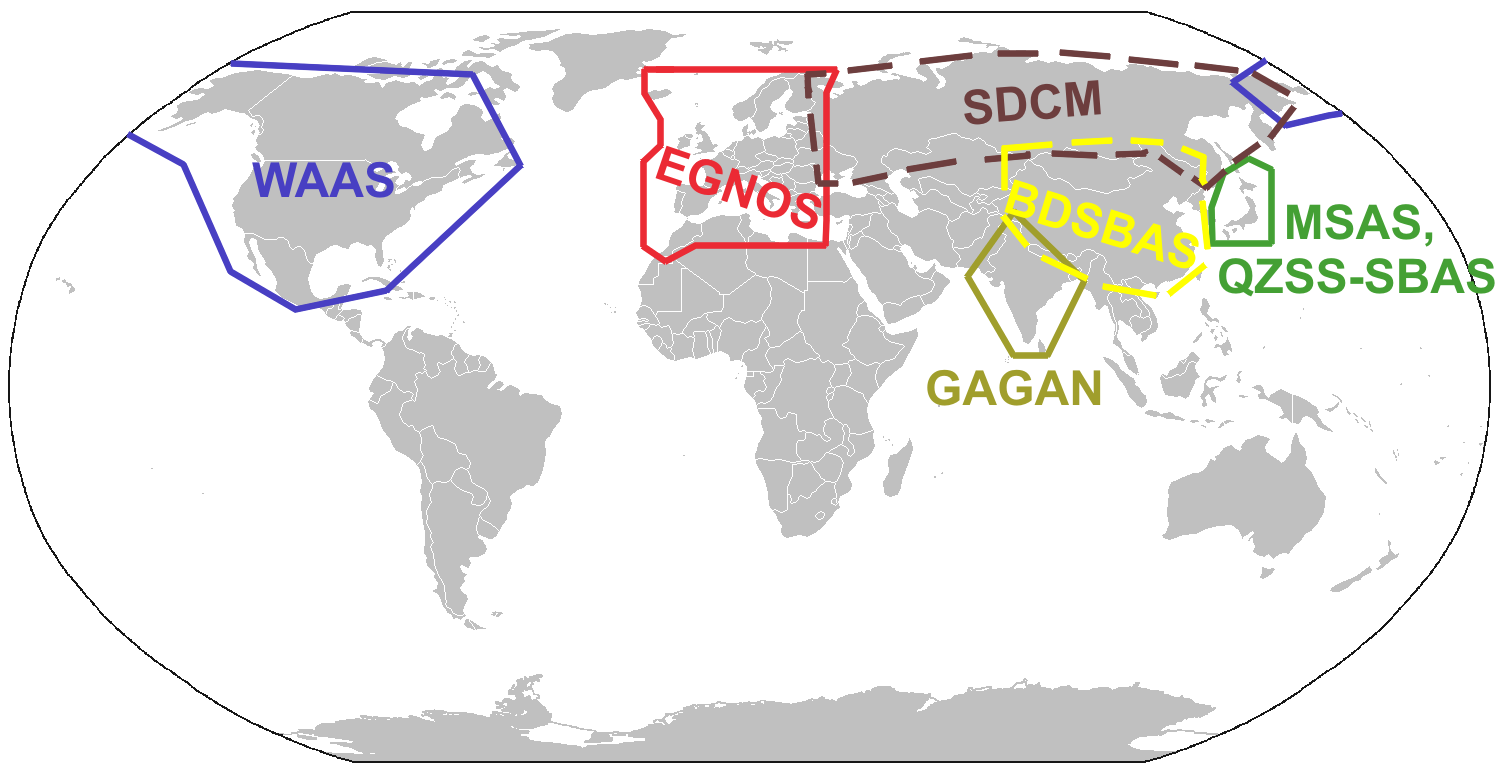
WAAS is a Satellite Based Augmenation System (SBAS). WAAS stands for Wide Area Augmentation System. WAAS is another satellite or constellation that broadcasts correction values to GPS receivers. The WAAS system has a few ground based systems at known locations measuring the difference from the GPS broadcast position and where the location really is. Receivers listening to the WAAS signal can adjust the calculated GPS position using the known difference to be more accurate.

Any aircraft flying relying completely on GPS navigation is required to make a pre-flight check. If the receiver is using the C-129 or C-196 standards, then a full RAIM prediction must be made. The above map at http://www.raimprediction.net is sufficient. For aircraft using the C-145/146 standard receivers, then a check for GPS NOTAMs is required.

GPS Receiver Systems

A typical aviation GPS receiver is really a system. The GPS receiver can only tell you where it is. Typically the GPS receivers are connected to computers that are watching where they have been, and projecting where they are going. There is a function that can be used to smooth out the path, and predict where everyone is going called a Kalman Filter. There is some mapping software that holds the location of most of the waypoints for the region. The computer is also connected to a display to the pilot can see where they are, and enter a flight plan.


Next time I will talk more about augmentation systems. The third part will be about RNP and ADS/B.

Thanks for reading, and I look forward to some feedback.

Monday, April 29, 2013

Batteries in Airplanes

Batteries seem to be a popular subject these days. Certainly the 787 has had it's share of trouble. Even a couple years ago, batteries in phones and laptops were catching fire, seemingly randomly. Mostly the fires have been harmless to people, but the equipment hasn't come out so well. During 2007 there were several laptops that spontaneously combusted Here is one (warning coarse language) http://www.youtube.com/watch?v=mlZggVrF9VI. Several manufacturers had recalls, and since then, there haven't been too many laptops that caught fire..

About the time everyone figures the trouble is over, people start getting burned with cell phones in their pocket. I have a couple batteries from my previous phone that are slightly bulged. The bulges signify something bad happening on the inside of the case. Bulging is a mechanical function, charging is normally a simple exchange of electrons.

I don't know the details of the 787 exactly, just what I have read, and the pictures I've seen. It seemed the original design had multiple cells packed together inside of the blue box. The new design has insulation between cells, and the cells are isolated. Lithium batteries are more likely to fail when heated. If one cell is misbehaving and getting warm, and touching another cell, the non-warm cell is more likely to do something bad, even though everything about it is normal. The misbehaving cell will inspire the adjacent cell to enjoy its company. Their friends may joint in, being neighborly, and things are getting quite hot now. The heat seems to multiply, especially being in a box, and suddenly there is smoke coming out.

There is a theory that all electronics run on smoke. When the smoke gets out, they quit working. Batteries tend to be the source of smoke for many electronics, so when the smoke gets out of them, things really don't work.

Why would anyone put something that dangerous in their airplane? As Collin Chapman used to say about building race cars, "Simplify, then add lightness", or Burt Rutan used to say, "Throw it up, if it comes down, it doesn't belong on your airplane". Basically what these people are saying, that making things light is the proper way to build airplanes, and cars. Why lithium? Look at this table:

    -----------------------------------------------
      Fuel        |             Watts / Kilogram
    -----------------------------------------------
    Lead Acid     |            0.05
    -----------------------------------------------
    Lithium       |            0.224
    -----------------------------------------------
    Gasoline      |           12.88
    -----------------------------------------------

Lithium batteries are much lighter per unit of work (watts).

Wow, that does seem dangerous, or does it. Well, it is significantly more dense than a lead acid (the traditional airplane battery, although some airplanes are now ni-cad powered), and quite a bit less dense than gasoline. No one carries gasoline in their pocket.

How much battery does an airplane need. I built and airplane once, and was told I only need enough battery to start the engine. Once the engine is started, then the Alternator should take over powering all the accessories. All the radios, gear retracting motors, and lights all run off the alternator. A bigger battery might be handy in case the alternator quits, but then you are hauling around a battery for every flight that you may never need. A second "back-up" battery is just extra weight that you haul around.

Airplanes should be designed so failures are an inconvenience, not a catastrophe.  If your alternator fails, you know the battery will be dead eventually. Once it fails, you can continue without radios and such, or you need to land before it gets dark. With a backup battery, you may continue farther, but you will still need to land soon.

In a modern jet airliner, there are alternators on each engine. Two seems like a good idea. There are actually 3, since the aircraft actually has a third turbine engine called the auxiliary power unit (APU). The APU is hidden in the tail of the aircraft, and connected to a generator capable of starting both engines, and running the majority of everything electric in the aircraft.

The 787 is unique, in that there is no hydraulic system to help the pilots fly the airplane. The items normally controlled by hydraulic fluid are run by servo motors, including control surfaces and brakes. The electrical system is quite important.

The batteries will help start the airplane. On the ground, there will usually be a device called a ground power unit (GPU) that will allow the aircraft to be started. The GPU can also be used to charge the batteries.  If the aircraft is operated away from the GPU, the battery will usually start the APU since that is a smaller turbine. Once the APU is started, it will be used to start the other engines.

Will the new battery solution help prevent a catastrophic failure on the 787. Probably, since the misbehaving battery cell will be isolated from its neighbor. Will there be cell failures? Probably, but the new monitor system will alert the pilots, and isolate the bad cell when needed.

If someone wants to have a wanna be engineer to ride around on the 787 during test flights, I'll volunteer. Give me a call, we'll set something up.


Saturday, April 27, 2013

Sequestration Ha!


I was going to write something about the furloughs and why they would cause the delays that they do, but I think everyone has heard enough. Now that they are over, it may not matter, but then again, how are they going to end...

So in a contract position, a fraction of the workforce was forced to reduce their work by 10%. Everyone is supposed be treated equal, so how can this be, not everyone had their work cut by 10%? How are they going to make it fair? The whole mess will take over a month to resolve, unless there is an emergency order, causing the folks who got the time off to be paid for the time they took off anyway (such a deal!).

I don't know if the whole deal was worked out yet. Sure congress got beat up, and something happened, but has the President signed off on it (does he need to, I am thinking he will eventually). The whole deal is a rob Peter to pay Paul anyway. No one authorized the FAA to spend what they used to spend, just that they can use some other money to pay the controllers. That money is still ready to be used for the projects it was originally intended to be used for, and someone else will be screaming if they don't get theirs.

Why do to furloughs cause delays? In a air traffic control center, there are various geographical regions that are covered, broken into sectors. Not all controllers are certified to work all sectors. The midnight shift will combine multiple sectors and work them together, where during the day, a single controller or team (RADAR (R) and Data (D) side) will work a single sector. If you don't have enough staffing, the number of controllers certified to work the sectors will be reduced.

One day the guy certified to work sectors 1,2 and 3 will have the day off, and the next day the guy certified to work sectors 2,4,6,8 will have the day off. Scheduling becomes a challenge. Then throw in vacations, and sick days, and some days you may only have one guy on a shift qualified to work sector 5 or something. For one guy to handle the sector, then only maybe 12 aircraft can be in the sector at a time. Maybe it is a gateway sector, and he is doing his best but that means that sectors 6 and 4 have to hold or slow down aircraft. Slowing aircraft has a ripple effect, and sectors 3 and 7 have to manage the aircraft coming into sectors 6 and 4 smartly (and so on).

Equipment went from same day repair to next day repair. It wasn't just the controllers on furlough, but tech support as well. If the only person who normally would be on staff certified to repair some piece of equipment was off that day, the equipment was out of commission. Maybe it was not terribly critical, but caused more inconvenience to the controller, they will have to slow even more.

So traffic backs up all day, and the airlines are taking delays. (travelers still bought tickets, and they want to get where they are going). There ends up being higher volumes of traffic at some airports until well into the midnight shift. The midnight shift that is short staffed with overlapping sectors. All the FAA can do is ask some of the night shift controllers to stay late (and pay them overtime) since the sectors will be impossibly full until even later. So everyone is taking a 10% paycut, but to make that work, the FAA has to pay overtime to some of the staff. 

Since the first week required one third to half the staff to take a day off, how is it that the other folks are going to balance that out? Again, with vacation and sick days, to make it fair, it'll probably take a month for everyone to have the same hours. I know it says that they will "fix" it by Monday, but how can that be? There were controllers who decided the whole government employment situation is silly, and took their retirement, or just quit once they got threatened with the furlough.


It kind of begs the question, who is in charge? Congress tells the FAA to cut spending, and the FAA says we can cut this or that expense, and congress says no, not that one. Why have any administrators if congress is just going to override their decisions. Tower closures were overridden. For many years the FAA has been trying to consolidate TRACONs and such to save money, but it seems someone in congress forces the FAA to not do it. Congress talks the big talk, cut, cut, cut, but when they do, they say "not that way".


Thursday, April 18, 2013

Routes to Nowhere

Even professionals do silly things sometimes. Take a look at this approach plate for Nashville Tennessee.
Click to Zoom
The other day I saw a route from MDW to this airport that was something like

   CARYN2 CARYN J73 BNA

It seemed ok, pretty simple. I remember a controller telling me once, you don't want a clearance to an airport, you want a clearance to your approach, especially in the radar environment.

Look at the plate again, BNA! that is a VOR on the airport, but it isn't an initial approach fix (IAF). The FIDDS intersection is the IAF for this approach. Even from the North to the 20's runways, BNA isn't an IAF. 

So this poor pilot was cleared to a VOR. What should the pilot do if he looses communication? Assuming this was a ICAO flight plan, the destination airport was in field 16, no big deal. ATC should know where you want to end up. But what should this pilot do when they get to the BNA VOR in the soup? (assuming they have ILS or VOR receivers but no COM, it could happen).

Even if the pilot had good radios, and was planning on the ILS 2L, what should the controller tell this poor pilot? Well he has to figure out a way to this approach. Using the 2's, no big deal, since BNA is mostly on the way to FIDDY. Imagine though, the pilot wanted to go to the 20's. The IAF for the ILS 20R is HIKRY. HIKRY is 20 miles to the north. The pilot still gets to fly 40 miles more than needed to plus two huge turns. It isn't that far, but the pilot is still in the airport traffic area and has the controller guessing what to  do with this aircraft, to keep the pilot out of the way of all the other aircraft.

If the flight plan were filed to the IAF, or better yet, to a transition point on a STAR, so the sequencing can be done easier. The controllers like to know where you are going as far out as practical. The controllers like more time to think, and plan ahead, knowing what is planned, things go smoother.

Probably the proper route would be (ICAO format):
     CARYN2 CARYN J73 PXV DCT FIDDS

Getting off of J73 at PXV is safe and about as direct as you can get. It is 128 miles and gets the aircraft on the ILS 2L without any questions. The controller can assume the aircraft is going on the ILS, assuming ATIS says ILS 2L approach is in use.

I am hoping this helps. Any other thoughts?